Trimble T7
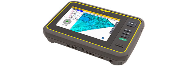
The Trimble® T7 Tablet is a lightweight, rugged handheld controller for GNSS or total station operations. The easy-to-use T7 Tablet allows contractors to work with larger, more complex 3D data sets more effectively in the field, connect to the office for on-the-spot approvals, and communicate changes to field crews. From the field to the truck cab, to the office, teams stay connected and work faster.
Key Features
Designed for construction site operations, the T7 Tablet offers integrated Wi-Fi® and Bluetooth®, built-in cameras, and GPS in a lightweight, shock, dust, and water-resistant package ideal for construction surveying, stockpile measurements, and grade verification.
- Monitor real-time cut/fill information to stay on top of operations
- Improve efficiency by making design changes in the field
- Access up-to-date data to support decision making
- The multi-touch screen works with a stylus, fingers, or capacitive gloves
- Lightweight and compact design, work all day with less fatigue
- Improve communications between the field and office by connecting more people on the job site
- Using front- and rear-facing cameras, video conference from the field for on-the-job support, and capture high definition videos and images of the site
- EMPOWER modules allow for use with 2.4GHz radios and Trimble Universal Total Stations
- Works seamlessly with Trimble Siteworks Positioning Systems software and hardware, everyone on the jobsite can use the same data and work on the same platform
Rugged Field Computer
The Trimble T7 Tablet is ruggedized to stand up to any construction site, in any weather. The vibrant display is powerfully illuminated, so you can finish any job fast, even in bright sunlight conditions. The long-life lithium-ion batteries are hot-swappable and ensure hours of field computing.
Applications
Whether you’re using a total station or GNSS, the T7 Tablet gives you total control over on-site tasks.
- Measure and verify original ground levels and site features
- Monitor real-time cut/fill information
- Check finished grade and laid material thickness against design elevations and tolerances
- Compute progress and material stockpile volumes
- Monitor and conduct quality control for earthworks and paving operations
- Assess as-built measurements and generate high-quality reports for record-keeping, approvals, and payments
- Synchronize design and field data via the Internet