Novapoint
Design complex 3D models efficiently.
Features and Benefits
Novapoint is a unique design software in Trimble’s extensive BIM solution for infrastructure projects. Civil Engineers can with Novapoint design complex 3D models and visualize in multiple ways to communicate effectively.
Efficiently build complex models of roads and railways, including 3D terrain surfaces, sub-surface layers and structures such as buildings, bridges, road signs, cables and vegetation. Intuitive and highly-effective functionality makes it possible to view the model in planes, sections and 3D. It is easier to navigate in 3D and understand the model – ensuring precise, consistent and sustainable results. Novapoint requires a connection to AutoCAD.
Trimble Novapoint Infrastructure Design Suite includes a suite of discipline-specific design applications for civil engineers; roads, utilities, landscape, tunnel, bridge, road marking, road sign and terrain (country specific). It is ready to use together with Quadri.
Trimble offers domain-specific modules to help you efficiently design complex 3D transport infrastructure models, to get precise, consistent, and sustainable results.
Comprehensive model-based design
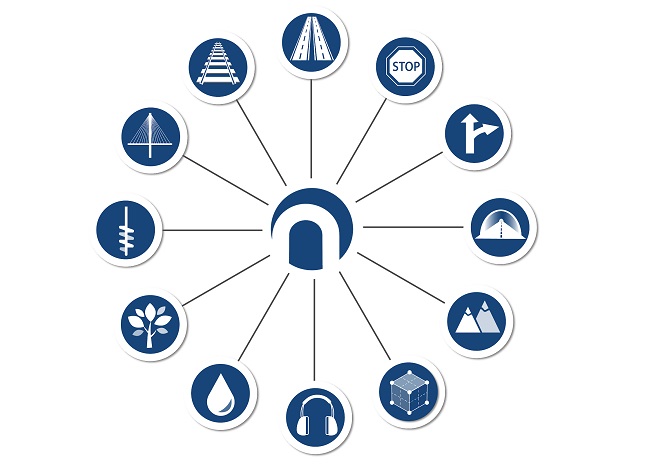
No matter what type of civil project you are working on designing, our easy to use 3D construction design software can help you get the job done. Novapoint infrastructure design toolset gives engineers the power to effectively design all aspects of modern roads and railways to create comprehensive model-based design to use throughout a construction project. Novapoint advanced software covers all design disciplines for infrastructure.
- Road design
- Railway design
- Drainage design
- Landscape design
- Terrain design
- Tunnel design
- Bridge design
- Road marking design
- Road sign design
Constructability built in from the start of the 3D model design
With Novapoint you can efficiently build complex models and share your models to be used in the construction phase and closing the traditional gap between office and field.
- Daylight surfaces with break lines, road superstructure, including deep blasting and soft spot removal
- 3D Manholes with stakeout point and lines, pipes, and ditch surfaces with material layers
- Road Sign plates ready for manufacturing
- 3D road marking with detailed material attribution
- Tunnel geology registration during construction
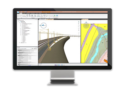
See real-world visualization as you design
With Novapoint’s deep integration with Quadri civil bim collaboration software, your design is continuously visualized in a virtual real-world environment. Using one design and one model creates more scale and efficiencies to save time and increase your construction productivity. There’s no need for an additional visualization tool when you choose Novapoint for your 3D design modeling software with any construction project.
- Design and visualize as one integrated construction workflow
- Experience the power of the 3D construction view, supporting trees, water, sky, traffic signs, buildings, etc.
- Terrain texturing from orthophotos or WMS
- New 3D design is always visible by the automated blending of corresponding existing terrain areas
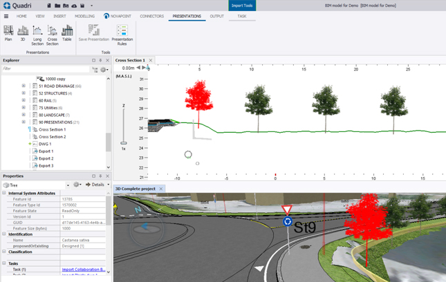
Information views from a shared model
Quadri integrates with Novapoint domain modules to provide an efficient design modeling software platform for harvesting information across all the domains. Your valuable construction data can be presented in a variety ways for multiple views to harness the power of construction technology to increase your productivity. View your 3D model and get accurate construction takeoff across the complete model and project.
- 3D view
- Visualizer view
- Long section view
- Cross section view
- Plan view
- Properties view